
{{product.productLabel}} {{product.model}}
{{#if product.featureValues}}{{product.productPrice.formattedPrice}} {{#if product.productPrice.priceType === "PRICE_RANGE" }} - {{product.productPrice.formattedPriceMax}} {{/if}}
{{#each product.specData:i}}
{{name}}: {{value}}
{{#i!=(product.specData.length-1)}}
{{/end}}
{{/each}}
{{{product.idpText}}}
... tap into any streaming data feed. ArcGIS GeoEvent Server provides connectors for a host of data streams including in-vehicle GPS devices as well as social media providers. Don't see what you need? Use the ArcGIS GeoEvent ...

Why GSE Fleet Management and GSE Fleet Tracking System-EnTrackGSE? THE GSE FLEET MANAGEMENT AND GSE FLEET TRACKING SYSTEM TAILORED FOR AIRPORTS No longer do you have to get a generic tracking system or fleet management system and ...
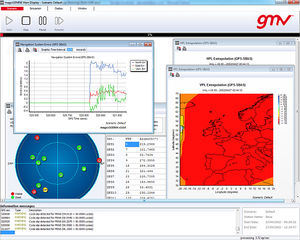
The Complete GNSS Performance Monitoring and Analysis System The Complete GNSS Performance Monitoring and Analysis System for the Aviation Community GMV has developed MagicGEMINI®, an operational GNSS performance analysis and monitoring ...
GMV
The flight planning features in SkyDemon are all designed to make planning a flight less tedious and more interesting, by bringing the very best aeronautical briefing information directly to your fingertips in real time as you explore ...
SkyDemon
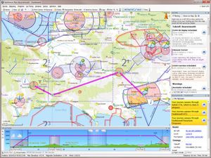
NAVCANsitu provides controllers with aircraft surveillance data and displays fused tracks on a situational display for enroute, terminal and ground air traffic control. Situ offers several layers of maps, insets, windows and tools to ...

A software product that collects, processes, and automatically broadcasts weather and safety-critical information to pilots about their airport departure/arrival conditions, thus automating the controller’s communication ...

Advanced Command and Control Software. ViewPoint is a ground-based control software application that displays video and command/control for Cloud Cap Technology TASE imaging payloads. User Friendly ...
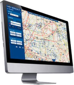
MACH 7 is a next-generation software for flight planning and GPS navigation for VFR pilots. It associates the advantages of web and tablets. Its main characteristics are the following: Total intuitiveness: ...
MACH 7

With RiSCAN PRO 2.0 RIEGL's well established Operating & Processing Software for 3D Laser Scanners starts a new area. The 64-bit architecture, geo-referencing support of GeoSysManager 2.0, as well as support for Ultra ...
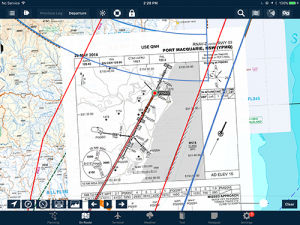
Overlay any geo-referenced approach plate on any map. Perfect for flying IFR with complex airspace, traffic or weather around your approach. Additionally, the airport diagram will appear on the map as you zoom into the airport.
AvPlan EFB

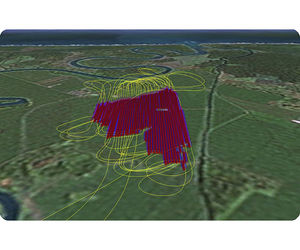
... not only a Bird Dispersal method as a vehicle-mounted system solution, but also provides Data Logging/Analysis/Reporting Software for helping airports to make and take informed choices on action to mitigate future bird ...
Scarecrow Bio-Acoustic Systems Ltd
RTD-Pro is a unique software solution for continuous monitoring of permanent GPS networks operating dual-frequency receivers.RTD-Pro provides Precise Instantaneous GPS positioning for ...
Geodetics, Inc.

... GALIOT WLM DIFFERENT? Integrated with Safety, Audit, Document and Staff Licenses/Training Management modules Affordable software-as-service (cloud) deployment for small and medium size airports Fast and straightforward ...
Visionair is UAV Navigation's (UAVN) standard Ground Control Station (GCS) software for planning and executing UAV missions. It is compatible with all UAVN autopilots (AP). Basic Features:Mission-oriented interfaceFully ...
SprayView allows you to create powerful flight reports. With both SprayView and NavViewW, you can create a detailed flight data report with spray data. SprayViewW allows you to create additional reports which can be customized with the ...
In order to take full advantage of any gimbal’s capabilities, a feature rich user interface is required. As opposed to alternative gimbal interfaces that were “designed by engineers for engineers” featuring pages of data, Trillium’s ...
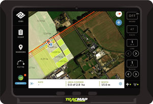
A Revolution In GPS Technology TracMap’s next generation GPS unit, brings a new level of usability and functionality to the industry. It has guidance patterns for every situation and state of the art ...
... form the computer software. The measured data are presented in real time and at the same time saved to database. Photos can be taken any time during the measurements and are added to the data. You may configure positions ...

TerraLens Core (Formerly InterMAPhics), is the high-performance geospatial visualization and mapping software development kit at the heart of the TerraLens geospatial platform. TerraLens Core has been optimized for spatial ...
KONGSBERG GEOSPATIAL
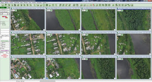
... Professional software are: - photoschemes, - photoplans, - digital relief models, - electronic maps and plans. Ortophotoplans, electronic maps and digital relief models created with the software ...
HITEC Luxembourg Dynamic Information Sharing Platform (DISP®) software is an efficient and interactive solution to obtain situational awareness and ensure people and resources safety. DISP® allows one to: Remotely ...
Please specify:
Help us improve:
remaining