
{{product.productLabel}} {{product.model}}
{{#if product.featureValues}}{{product.productPrice.formattedPrice}} {{#if product.productPrice.priceType === "PRICE_RANGE" }} - {{product.productPrice.formattedPriceMax}} {{/if}}
{{#each product.specData:i}}
{{name}}: {{value}}
{{#i!=(product.specData.length-1)}}
{{/end}}
{{/each}}
{{{product.idpText}}}

Maximum altitude: 7 km
Upgrade your next mapping mission with the Phantom 4 RTK – the most compact and accurate low altitude mapping solution. Next Generation Mapping DJI has rethought its drone ...

Maximum load: 5 kg
Autonomy: 23 min
Maximum altitude: 1,000 m
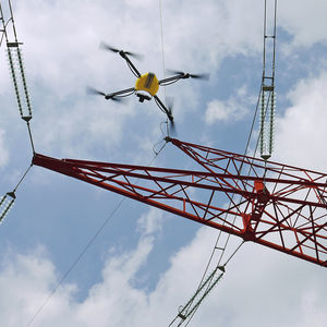
The Inspection drone is equipped with a Sony a7RM5 camera equipped with 61 megapixels and a 35 mm full-frame sensor. It is a drone that takes precise images of the structure from a free angle of 180′ ...
Gryphon Dynamics

Maximum load: 50, 10, 20, 40 kg
Autonomy: 25, 36, 20, 31 min
Maximum altitude: 1,000 m
... enables stable landing even in emergency situations. Currently, GD-225X is used in various industrial fields such as cargo drones for transportation such as pharmaceutical, fire fighting, forestation, or construction ...
Gryphon Dynamics

Maximum load: 40, 10, 20, 30 kg
Autonomy: 26, 20, 31, 36 min
Maximum altitude: 1,000 m
... enables stable landing even in emergency situations. Currently, GD-200X is used in various industrial fields such as cargo drones for transportation such as pharmaceutical, fire fighting, forestation, or construction ...
Gryphon Dynamics

Maximum load: 0 kg - 2 kg
Autonomy: 28 min
Maximum altitude: 3,000 m
The most compact drone of its class Deploy & Fly it: Perfect for Inspections and Photogrammetry , KUR-400 is the most advanced and compact drone in 4kg range. Its folding system grants maximum portability ...
UP - Caeli Via srl

Maximum load: 0 kg - 13 kg
Autonomy: 36 min
Demo Unit for Sale! Perfect for Mapping, Agriculture and Delivery, KUR-1000 is the most complete drone of our fleet. Its wide undercarriage area grants high payload capacity (up to 13kg) with minimum ...
UP - Caeli Via srl

Maximum load: 5 kg
Autonomy: 30 min
Maximum altitude: 3,000 m
Professional custom drone for standard and custom applications like mapping, inspections and delivery KUR-1000 is adopted in many applications thanks to its versatility and ease of usage. Improved ...
UP - Caeli Via srl

Maximum load: min 5.0 kg
Autonomy: min 2.0 h
Maximum altitude: min 3500.0 m
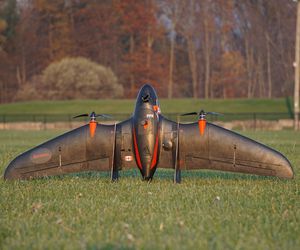
The CK 5 offers a unique combination of fixed wings and vertical take-off and lan-ding Therefore, no infrastructure or launching and recovery systems are needed The fixed wings design allows high speed and long endurance 100% ...
Maximum load: 600 g - 800 g
Autonomy: 20 min
Maximum altitude: 2,200 m
... more than ten years by the main players in the field of structure inspection, the U130 micro-UAV is a real inspection and airborne measuring tool. The U130 micro-UAV solution integrates into the inspection ...
Maximum load: 500 g
Autonomy: 90 min
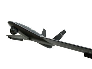
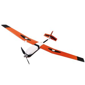
... drone, is an innovative aerial solution meticulously designed to cater to diverse applications, including high-precision mapping, surveying, inspection, scouting, observation, and agriculture, covering very large areas ...
Aeromao Inc.

Autonomy: 90 min
Maximum altitude: 30 km
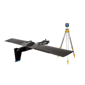
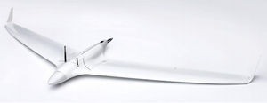
... required. The drone allows for easy operation thanks to its autonomous take off upon hand launch, autonomous navigation, and auto land. Best of all, forget about paying an arm and a leg for a dependable – portable ...
Aeromao Inc.

Autonomy: 2 h
Maximum altitude: 400'00"
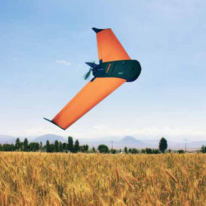
... fixed-wing mapping drone. This sUAS turnkey system is ideal for ultra-accurate data collection, scouting, monitoring, mapping, and surveying thanks to its swappable payloads. Among the payloads available ...
Aeromao Inc.

Maximum load: 5, 9 kg
Autonomy: 2 h
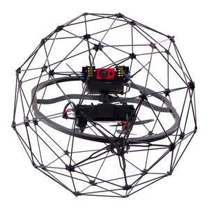
GT20/ GT25 Gyrotrak is Airial Robotics‘ super versatile super Workhorse. A disruptive gyro/helicopter hybrid UAV solution advancing flight time, payload, range and speed over other systems. GT20/ GT25 is built for BVLOS ...

Autonomy: 50, 32 min
... flight time of a fixed wing but the precision of a quadcopter. The capture resolution of a quad copter allowing precision mapping of more complex areas such as construction sites and open mines. With the Long Range FPV ...
Maximum load: 0 kg - 3 kg
Autonomy: 150 min - 180 min
Maximum altitude: 5,000 m
Product Name : Accipiter Product Description Long Endurance : 2.5~3hr Max payload : 3kgs With RTK/PPK technique : NO NEED of GCPs Photo area(AGL 500m) : 30sq-km
Uaver
Autonomy: 70 min - 90 min
Maximum altitude: 4,000 m
... to complete a landscape survey, thanks tothe invention of unmanned aerial vehicles and drones, surveyors can simply set up UAV with RTK and PPK chipsets inside and complete their job in no time.
Uaver
Autonomy: 40 min
Maximum altitude: 100 m - 3,000 m
In meeting with all kinds of different mission, BESRA can fly for more than 40+ minutes and is equipped with professional flight control system that can work with multiple payloads as options. Its real-time transmission image allows ...
Uaver

Maximum load: 2 kg
Autonomy: 180 min
Elektra VTOL is an electric powered vertical takeoff and landing (eVTOL) drone with a payload capacity up to 2kg. A highly advanced aerodynamic airfoil and an advanced wing design allow for a flight endurance up to 3 ...

Maximum load: 7 kg
Autonomy: 3 h
Maximum altitude: 10000'00"
... weight and capabilities, it creates a class on its own and brings industrial reliability into the UAV market in an unprecedented small size. High Eye believes a UAV should be safe to operate under nearly ...
Maximum load: 1 kg
Autonomy: 180 min
Maximum altitude: 3,000 m
The HIRRUS mini‐UAV system featured in this document exhibit various applications, but for the scope of this document, it focuses on the ones considered related to photogrammetry, detection, monitoring and surveillance ...

Autonomy: 0 min - 50 min
The professional mapping drone Use this fully autonomous drone to capture high-resolution aerial photos that you can transform into accurate orthomosaics & 3D models.

Autonomy: 0 min - 50 min
The survey-grade mapping drone Capture aerial photography to produce orthomosaics & 3D models with absolute accuracy of down to 3 cm - without Ground Control Points.

The intelligent mapping & inspection drone Meet albris, the sensor-rich drone for professionals, offering TripleView imaging and advanced situational awareness.

Autonomy: 0 h - 10 h
Stratus engineered and manufactured Venturer is a large fixed-wing UAV. The Venturer has extensive flight time capabilities and is a top choice for its reliability, robust build, and harsh aerial condition deployments.

Maximum load: 18, 20 lb
Autonomy: 14,400, 108,000, 90,000 s
Maximum altitude: 14763'00", 300'00", 25000'00"
The TD100 UAV platform is based upon a proven conventional layout with high wing and t-tail configuration, and provides a flexible and stable base platform for a wide variety of mission specific modifications. The aircraft ...

Maximum load: 1.5 kg
Autonomy: 1,620 s
Maximum altitude: 5,000 m
Advanced Features As the results of latest improvements from OnyxStar®, XENA is a highly professional drone. It has been designed in accordance to robustness, quality, versatility and efficiency fundamentals.

Maximum load: 2 kg
Autonomy: 1,800 s
Maximum altitude: 5,000 m
Improved version of the FOX-C8, the OnyxStar FOX-C8 HD is a robust, efficient and multi use drone. It is made to successfully perform any kind of aerial operation a multirotor can be given. Powerful and adaptive, the FOX-C8 HD benefits ...

Maximum load: 9.1 kg
Autonomy: 14 h
... networking (MANET) Synthetic aperture radar (SAR) EW Signals intelligence (SIGINT) Communications intelligence (COMINT) 3D mapping Automatic identification systems (AIS) CONFIGURATIONS AEROSONDE® FIXED WING Textron ...

Maximum load: 700 kg
Autonomy: 16 h
Maximum altitude: 500 m - 7,000 m
... medium-altitude UAV system developed from existing matured system. The type is capable of sensing remotely with high definition,multi-payload in limited time. Harrier Hawk is designed for a wide range of mission including ...

... Video Management System (supervisor) or by being fully integrated into a hypervisor. Autonomous drone Very fast and stable, the ISS SPOTTER® Automatic drone can fly 1200m in less than 2 minutes (maximum ...

Autonomy: 80 min
Maximum altitude: 5,000, 6,000 m
... fixed-wing professional mapping drone offering significant productivity gains, unprecedented ease of use and high quality aerial data acquisition. The Delair UX11 is an ideal drone ...
DELAIR-TECH
Maximum load: 0.3 kg
Autonomy: 0 min - 15 min
FlyFast 2.0 is a lightweight fixed wing UAV for use in applications such as oil and gas pipeline inspections, archeological site surveys, precision agriculture, photogrammetric surveys and land mapping ...

Maximum altitude: 40 m - 100 m
... following tasks. Digital twin creation and maintenance Corridor mapping Mining (volume calculation) Construction site monitoring Environmental changes (time series) Forestry Contour mapping Planning, ...
microdrones

Maximum load: 13 kg
Autonomy: 14 h
The JUMP 20 is a vertical takeoff and landing (VTOL), fixed-wing unmanned aircraft used to provide advanced multi-sensor intelligence, surveillance, and reconnaissance (ISR) services. Delivering 14+ hours of endurance and an operational ...
AEROVIRONMENT, INC.
... bringing their inspections and mappings to the next level. Much more than a flying camera, Elios 3 is a powerful data-harvesting tool. Relying on the power of computer vision and LiDAR mapping, Elios ...

Maximum load: 23 kg
Autonomy: 20 h
Maximum altitude: 100 km
... payloads, Penguin C is one of the most capable surveillance and inspection UAS available on the market. CLASS LEADING MOBILITY A crew of two can operate the Penguin C UAS and all the necessary equipment, ...
Please specify:
Help us improve:
remaining