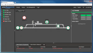
... A web-based software application offering airport maintenance personnel (ATSEP) with centralized monitoring capability of all of their mission-critical systems: NAVAIDS, Radars, Radios, MET systems, Servers/Workstations, Gensets/UPS, ...

... wind speed and direction, air and sea temperature, relative humidity, barometric pressure, visibility and present weather, cloud height and wave height. In addition, the IMS4 Helideck monitors the helideck’s heave, heave velocity, roll, ...
... Preventive maintenance solution by remote system monitoring software BV TELEMETRY is an advanced software solution that helps baggage inspection systems operators to monitor, manage and optimize manipulations with ...

... RDBLib is a software library for reading and writing various types of data (e.g. point clouds, trajectories, voxels) from and to RIEGL‘s native RDB file format. The free software package enables software ...
RIEGL LASER MEASUREMENT SYSTEMS GMBH

... Phoenix Cloud Viewer displays detailed LiDAR data that can be a challenge for some computers. For the best experience: We recommend Chrome/Safari with few or no other tabs open Once the point cloud opens, click the ...
Phoenix LiDAR Systems
... LATITUDE’S SOFTWARE EXPERTS ARE CAPABLE OF DEVELOPING SOFTWARE TO SUPPORT A WIDE RANGE OF APPLICATIONS: Firmware development for a broad spectrum of embedded systems used in the unmanned vehicle arena. Autopilot feature/function ...
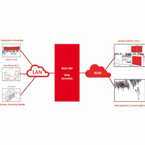
Barco’s Web Streaming Gateway (WSG) solution is a remote networking addition to Barco’s TransForm N and CMS control room and collaboration products. WSG enables the control room operator (using Barco CMS as the main control room management tool) to select ...
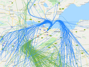
... Build community engagement by sharing information with community members Transparency and information are key to building a relationship with your community members. Our public flight tracker is easy to use and provides powerful tools to help residents ...
Casper

... AvPlan Cloud Manage all devices in your organisation from our cloud management platform. Manage licensing, report on software versions, data versions and upload custom charts ...
... Support to operator (dedicated E-tool) • Multifunction E-tool in the aeronautical domain • On-line maintenance of passenger seats : → Check list → Reporting → Management of the current and postponed works → Inventory management ...

... 360TM is the first 3D CAD, CAM, and CAE tool of its kind. It connects your entire product development process in a single cloud-based platform that works on both Mac and PC. ...
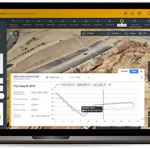
... Turning construction data into insight DatuBIM is an automated software-as-a-service (SaaS) cloud platform designed and built for infrastructure construction projects. It enables construction companies to monitor project ...

... application for defined access on the HiCo iLS.Suite®. The HICO X-ContentSuite® is based on the HiCo iLS.Suite® and complements the online access with different functionalities. With the HiCo X-ContentSuite®, external persons like technicians, ...

... Our AvR.eFuelling platform combines extensive experience with contemporary design to provide an unrivalled solution for all airport refuelling operations. Each user in the into-plane operation is able to access information relevant to them, allowing ...
... Geographic Information System) software, also working in Open-Source, that allows the management of existing obstacles, in addition to the possibility to identify new ones by means of three-dimensional analysis made by the software ...

... unrivalled insight and power. Deliver transformational change to your infrastructure. Full software control Fully automated and optimized for each deployment with software defined acquisition sensing parameters such ...

... Low-code cloud-native platform to automate engineering processes and enable Digital Twins at scale: Access to engineering automation, design optimization and predictive modeling functionality right in your browser. Collaborate easily ...

... A cloud-based, quick, and easy self-service check-in solution, uniquely designed to solve the issues faced by airports and carriers using traditional common use self-service systems. Combining proven software and hardware ...
ICTS Europe Systems Ltd
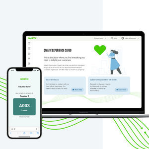
... Great experiences on demand Qmatic Experience Cloud is an intuitive, dynamic all-in-one platform for effortlessly delighting your customers, empowering your people, boosting your operations – and adapting on the fly. Just add what you ...

... Cargo Flash Door to Door System - Web based door to door solution starting from web booking to a high degree of information for schedules, multiple frequencies, pricing, track & trace and customer business/account information. Key Features:- There are ...
Cargoflash Infotech Pvt. Ltd.
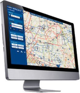
... MACH 7 is a next-generation software for flight planning and GPS navigation for VFR pilots. It associates the advantages of web and tablets. Its main characteristics are the following: Total intuitiveness: no user manual is needed A ...
... insightAutomatic data processing and secure online storage provide a solid foundation for quick or in depth analysis and simple reporting in an easy-to-use interface.Automated volumetrics and reportingThe Kespry Cloud ...
... Our Cloud Service stores and processes the 3D point clouds and annotations to facilitate rich intelligent 3D models, making them available in near realtime to customers. ...

... drone test areas wishing to implement U-Space and UTM Airspace or deploy specific drone operations. The unique complete Software and Hardware solution to enable complex drone operations such as BVLOS missions Decisive air risk mitigation ...

... them to produce this information accurately, reliably and efficiently. The inforMET software application is such a tool. The primary function of the inforMET software is to maximize the productivity of weather observers ...
the best suppliers