
{{product.productLabel}} {{product.model}}
{{#if product.featureValues}}{{product.productPrice.formattedPrice}} {{#if product.productPrice.priceType === "PRICE_RANGE" }} - {{product.productPrice.formattedPriceMax}} {{/if}}
{{#each product.specData:i}}
{{name}}: {{value}}
{{#i!=(product.specData.length-1)}}
{{/end}}
{{/each}}
{{{product.idpText}}}

... Integration details
ArcGIS for Autodesk Forma operates inside Autodesk Forma Site Design (
cloud-based early-stage design and analysis) and connects to ArcGIS
Online or ArcGIS Enterprise to surface up-to-date organizational ...
ENVIRONMENTAL SYSTEMS RESEARCH INSTITUTE, INC.
... Manage continuous data streams and configure feeds to ingest live sources as map and dashboard layers.
- Connect to cloud IoT platforms, sensor APIs, and messaging brokers using preconfigured provider integrations
- Integrate
ENVIRONMENTAL SYSTEMS RESEARCH INSTITUTE, INC.
... attribute population.
How it works
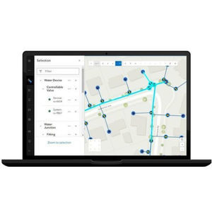
ArcGIS Web Editor consolidates core editing ...
ENVIRONMENTAL SYSTEMS RESEARCH INSTITUTE, INC.
... stakeholder engagement tools, online feedback and project e-submission workflows.
ENVIRONMENTAL SYSTEMS RESEARCH INSTITUTE, INC.
... elevation models (DSM/DEM), point clouds, 3D meshes, and Gaussian splats for construction sites, urban areas, and regional mosaics.
ENVIRONMENTAL SYSTEMS RESEARCH INSTITUTE, INC.
... advanced mapping, spatial analysis and authoritative data management. Part of the Esri ArcGIS platform, it integrates with ArcGIS
Online and ArcGIS Enterprise to support sharing, collaboration and enterprise workflows.
Key capabilities
ENVIRONMENTAL SYSTEMS RESEARCH INSTITUTE, INC.
... seamlessly links architecture, engineering, and construction (AEC) information in Autodesk Forma (formerly Autodesk Construction Cloud) with geospatial data and services in ArcGIS. By bringing these tools together, teams can smoothly ...
ENVIRONMENTAL SYSTEMS RESEARCH INSTITUTE, INC.

... ArcGIS Online is a secure and scalable software as a service (SaaS) for your geospatial workflows. Improve decision-making by collecting and managing data, analyzing it, and easily sharing maps and apps within a connected ...
ENVIRONMENTAL SYSTEMS RESEARCH INSTITUTE, INC.

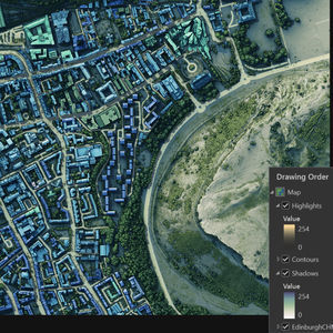
... Imagery hosting, streaming, and analysis in the cloud ArcGIS Image for ArcGIS Online is a complete software as a service (SaaS) offering for hosting, analyzing, and streaming imagery and raster collections. ...
ENVIRONMENTAL SYSTEMS RESEARCH INSTITUTE, INC.
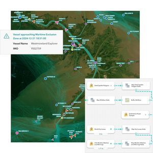
... Gain situational awareness of your real-time streaming data with ArcGIS GeoEvent Server, part of the Esri Geospatial Cloud. Whether you are tracking moving assets, monitoring stationary sensors, or following social media feeds, you can ...
ENVIRONMENTAL SYSTEMS RESEARCH INSTITUTE, INC.