
- Company
- Products
- Catalogs
- News & Trends
- Exhibitions
Professional UAV CK 7 mappinginspectionsurveillance


Add to favorites
Compare this product
Characteristics
- Domain
- professional
- Applications
- mapping, surveillance, inspection, civil defense, security, topography
- Type
- bi-rotor
- Engine type
- electric motor
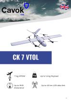
- Weight
7 kg
(15.432 lb)
Description
The CK7 is the ultimate tool for topographie mapping, land survey, précision agriculture missions, combining extended range, endurance and precision in a design optimised for demanding operations.
In mapping and surveying, its range of 3 hours and 15 minutes allows it to cover large areas in a single flight, reducing operational time and costs. Its stability and wind resistance up to 20.5 knots ensure accurate geospatial data even in adverse conditions. In addition, its 1.5 kg payload capacity allows the integration of high-precision sensors, optimising data collection for topographic surveys, 3D modelling and land planning.
For surveillance and security, the CK7 offers continuous monitoring with a maximum cruising speed of 22 m/s, ensuring efficient coverage and fast response in sensitive areas. In cargo transport, its capacity and autonomy make it a reliable solution for the delivery of essential supplies to remote areas, streamlining operations in logistics and emergency sectors.
More than a drone, the CK7 is a platform designed to optimise each mission with reliability, efficiency and precision.
VIDEO
Catalogs
CK 7 VTOL
7 Pages
Other Cavok UAS products
Solutions


Related Searches
- Drone
- Professional drone
- Electric motor drone
- Surveillance drone
- Rotary wing drone
- Fixed-wing drone
- Inspection drone
- Mapping drone
- Civil defense drone
- Quadcopter UAV
- Agricultural drone
- Search and rescue drone
- Transport drone
- Firefighting drone
- Drone for the construction industry
- Security drone
- Topography drone
- Drone for the mining industry
- Heavy lift drone
- Octocopter UAV
*Prices are pre-tax. They exclude delivery charges and customs duties and do not include additional charges for installation or activation options. Prices are indicative only and may vary by country, with changes to the cost of raw materials and exchange rates.