
{{product.productLabel}} {{product.model}}
{{#if product.featureValues}}{{product.productPrice.formattedPrice}} {{#if product.productPrice.priceType === "PRICE_RANGE" }} - {{product.productPrice.formattedPriceMax}} {{/if}}
{{#each product.specData:i}}
{{name}}: {{value}}
{{#i!=(product.specData.length-1)}}
{{/end}}
{{/each}}
{{{product.idpText}}}

... Support for real-time monitoring and interactive linked elements.
Use cases and examples
- Real-time
ENVIRONMENTAL SYSTEMS RESEARCH INSTITUTE, INC.
... Integrate with open-source and third-party technologies
Real-time analytics
Evaluate events as they arrive ...
ENVIRONMENTAL SYSTEMS RESEARCH INSTITUTE, INC.

... Overview ArcGIS Knowledge is enterprise knowledge graph software that enables organizations to combine spatial and nonspatial, structured and unstructured sources to reveal entities and relationships for faster, data-driven decisions. ...
ENVIRONMENTAL SYSTEMS RESEARCH INSTITUTE, INC.

... controls: apply renderers, edit band combinations, and adjust dynamic range (DRA), gamma and other display settings.
ENVIRONMENTAL SYSTEMS RESEARCH INSTITUTE, INC.
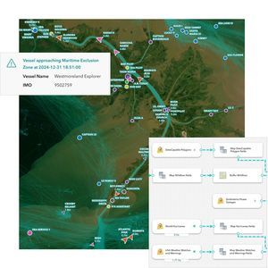
... your real- time streaming data with ArcGIS GeoEvent Server, part of the Esri Geospatial Cloud. Whether you are tracking moving assets, monitoring stationary sensors, or following social media feeds, you can tap into, analyze, ...
ENVIRONMENTAL SYSTEMS RESEARCH INSTITUTE, INC.

... critical incident mapping tools to visualize where resources and personnel are to coordinate team movement. Update your map in real time based on updates from the field and across command centers. Persistent communication Stay ...
ENVIRONMENTAL SYSTEMS RESEARCH INSTITUTE, INC.

... ArcGIS Pro, the powerful single desktop GIS application, is a feature-packed software developed with enhancements and ideas from the ArcGIS Pro user community. ArcGIS Pro supports data visualization; advanced analysis; and authoritative ...
ENVIRONMENTAL SYSTEMS RESEARCH INSTITUTE, INC.