
{{product.productLabel}} {{product.model}}
{{#if product.featureValues}}{{product.productPrice.formattedPrice}} {{#if product.productPrice.priceType === "PRICE_RANGE" }} - {{product.productPrice.formattedPriceMax}} {{/if}}
{{#each product.specData:i}}
{{name}}: {{value}}
{{#i!=(product.specData.length-1)}}
{{/end}}
{{/each}}
{{{product.idpText}}}

The next-generation of integrated UAV LiDAR solutions. With Livox technology, YellowScan sets new standards for UAV LiDAR mapping. YellowScan Mapper LiDAR ...
HEIGHT TECH Benelux B.V.

The next-generation of integrated UAV LiDAR systems, a long-range & multi-platform LiDAR solution offering more system accuracy at much higher altitudes. YellowScan Explorer LiDAR ...
HEIGHT TECH Benelux B.V.

The best-in-class long-range laser scanning system producing survey-grade point cloud data. Draganfly’s Long Range LiDAR (DLR- LiDAR) system provides accurate distance measurements ...

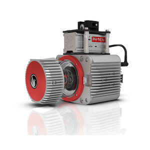
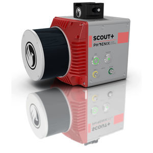
... market. The new Phoenix LiDAR AIR NavBox offers the most industry-altering capabilities in a tiny box not much bigger than a standard-size computer mouse. Dimensions (W x D x H) 58.5 x 123 x 48.1mm Weight 450g Phoenix ...
Phoenix LiDAR Systems

... SYSTEM The RANGER-ULTRA is an airborne laser scanner with an impressive combination of weight, range, accuracy and pulse rate. It is equipped with a unique forward and rear looking FOV designed to minimize laser ...
Phoenix LiDAR Systems

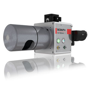
... resolution cameras on the market.The new Phoenix LiDAR AIR NavBox offers the most industry-altering capabilities in a tiny box not much bigger than a standard-size computer mouse. Custom LiDAR Solutions Phoenix ...
Phoenix LiDAR Systems
... demanding mapping applications, the RANGER-LR LITE is the ultimate combination of high density, long range LiDAR with a powerful 1,550 nm laser that penetrates dense vegetation at high speeds and altitudes ...
Phoenix LiDAR Systems
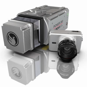
BEST IN-CLASS UNIVERSAL SURVEY GRADE LiDAR MAPPING SYSTEM The PIONEER-360 is a best-in-class universal survey grade LiDAR mapping system. It is the tool of choice for UAV and Mobile ...
Phoenix LiDAR Systems
... cameras on the market. The new Phoenix LiDAR AIR NavBox offers the most industry-altering capabilities in a tiny box not much bigger than a standard-size computer mouse. Custom LiDAR Solutions Phoenix ...
Phoenix LiDAR Systems
... major AGL gap in the ultra-lightweight UAV LiDAR market. With the photogrammetry package, operators of mid-size multirotors, like the DJI M600 Pro or the DJI M300 RTK, can now simultaneously acquire ...
Phoenix LiDAR Systems
... trusted SCOUT lineup of multi-channel mapping scanners. Long range, high pulse rate and triple return capability allow for UAV acquisitions of more data faster through vegetation. Dense survey data can be collected ...
Phoenix LiDAR Systems

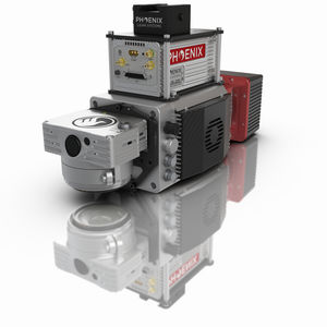
... thermal imaging, and more. Flexibility in sensing and mounting options is a key benefit of this Phoenix system. Phoenix LiDAR Systems Build the system you need to meet the growing demands of your clients in varying ...
Phoenix LiDAR Systems
UAV LiDAR FOR LIGHT VEGETATION & MEDIUM-RANGE SCANNING The Phoenix Scout-32 is a powerful, yet compact, mid-range member of the Scout Series. This lightweight system collects survey-grade data with an ...
Phoenix LiDAR Systems

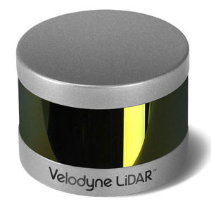
Velodyne LiDAR's ULTRA Puck™ VLP-32C is the newest long-range LiDAR sensor in its product portfolio that combines best-in-class performance with a small form factor. A high-resolution LiDAR ...
Velodyne

Expanding on Velodyne LiDAR's groundbreaking VLP-16 Puck, a 16-channel, real-time 3D LiDAR sensor that weighs just 830 grams, Puck Hi-Res is used in applications that require greater resolution in the ...
Velodyne
Velodyne LiDAR's Puck LITE™ is a lighter weight version of the VLP-16 PUCK for applications that demand a lower weight to meet their requirements. The Puck LITE™ has identical performance to VLP-16 with the only difference ...
Velodyne

... advanced product in Velodyne's 3D LiDAR product range. Vastly more cost-effective than similarly priced sensors, and developed with mass production in mind, it retains the key features of Velodyne's breakthroughs in LiDAR: ...
Velodyne

... EXCEED THE DEMANDS OF THE MOST CHALLENGING, REAL-WORLD INDUSTRIAL APPLICATIONSThe HDL-32E LiDAR sensor is small, lightweight, ruggedly built and features up to 32 lasers across a 40° vertical field of ...
Velodyne

... mobile data collection and mapping applications. The HDL-64E's innovative laser array enables navigation and mapping systems to observe more of their environment than any other LiDAR sensor.
Velodyne

drones, mapping, surveying, infrastructure, Urban Planning, Forestry, Construction, Mining, Agriculture, mobile mapping, MMS, integrated with GPS
Please specify:
Help us improve:
remaining