
{{product.productLabel}} {{product.model}}
{{#if product.featureValues}}{{product.productPrice.formattedPrice}} {{#if product.productPrice.priceType === "PRICE_RANGE" }} - {{product.productPrice.formattedPriceMax}} {{/if}}
{{#each product.specData:i}}
{{name}}: {{value}}
{{#i!=(product.specData.length-1)}}
{{/end}}
{{/each}}
{{{product.idpText}}}
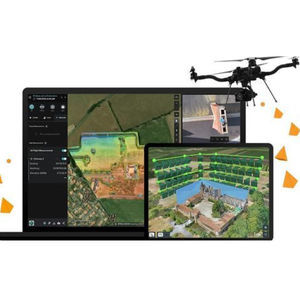
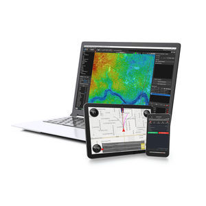
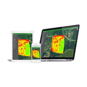
... for ArcGIS, part of the ArcGIS Reality product suite, is an end-to-end, cloud-based drone mapping and analytics software that manages image capture, processing and drone analytics. The platform supports ...
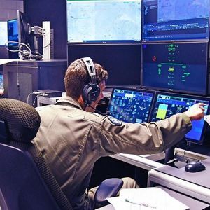
... command of multiple
unmanned air systems in the UK and has been demonstrated controlling the first flight of the MQ-25A Stingray™.
Technical specifications
- Open architecture C2 software platform
- Software-first

... required to guarantee the correct operation of drones. It implements a connectivity layer though which the different actors of the system may exchange information and services: service operators (USPs), drone information ...
INDRA
... business days for the license key to be generated. Description Intelligent Photogrammetry: Agisoft Metashape is a cutting edge software solution, with its engine core driving photogrammetry to its ultimate limits, while the whole system ...

... system and person adaptation Cuts integration costs Boots integration process Take service inter-operability beyond DRONE DETECTION The solution is designed to enable holistic management of events from detection through Air Defense ...
... in other U-space applications. The Dronelocus® tracking service manages data from several tracking sensors installed in drones. This service implements a Track Fusion algorithm to merge the data from different sensors. Additionally, ...

... Process, analyze, and maximize drone survey data, producing valuable information and deliverables CREATE POINT CLOUDS FROM UAV RAW DATA Transform and quailty control LiDAR and image data collected from your drone ...

... your inspections with Inspector 4.0. An easy-to-use software solution developed to allow asset operators to make fast, data-driven decisions. Without the right management solution, acting on raw drone data can be a ...

... Drone operators that run through their pre-flight checklist often struggle with the weather check. Weather conditions, especially winds, are one of the strongest external factors that challenge drone performance. Strong ...
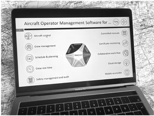
... FLEETPLAN Quality Management is the most comprehensive solution tailored for the specific needs of aircraft operators, design, maintenance and support organizations. Full 360° high performance management of regulation documentation implementation on ...
... Visionair is UAV Navigation's (UAVN) standard Ground Control Station (GCS) software for planning and executing UAV missions. It is compatible with all UAVN autopilots (AP). Basic Features:Mission-oriented ...
... BootCamp Windows, but again, it is up to you to decide which hardware & software you want to use. The ground software has been developed using all the lesson learnt with the contact of UAV operators. ...
Airelectronics

... RiUNITE is the core software module for LiDAR data processing in RIEGL's RiPROCESS point cloud management suite for kinematic laser data. It facilitates the four main tasks required for accurate point cloud generation. - Waveform ...
... Phoenix LiDAR Systems provides its proprietary software suite for streamlined acquisition, geo-referencing, data fusion & export, with your system purchase. Support for new cameras (e.g. PointGrey Ladybug5, RGB DSLR cameras, thermal ...
Phoenix LiDAR Systems
... LATITUDE’S SOFTWARE EXPERTS ARE CAPABLE OF DEVELOPING SOFTWARE TO SUPPORT A WIDE RANGE OF APPLICATIONS: Firmware development for a broad spectrum of embedded systems used in the unmanned vehicle arena. Autopilot feature/function ...
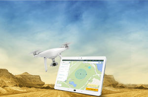
... Complete software platform for drones. Everything you need to automate your UAS operations, manage equipment and teams, fly safely, and analyze your data on our cloud-based platform and mobile app. ...
AgEagle

... ERMS is a proprietary software system that enables command and control of a single or multiple remotely operated drones, while transmitting high-definition optical and thermal video in real-time. ERMS can be securely ...
... FLIGHT PLANNING DRONE APP FOR HIGH RESOLUTION PHOTOSHOOTING Designed for land surveying, construction and infrastructure mapping, DatuFly™ drone app optimizes flight and image capturing per job type. The image taking ...

TopXGun ground station is specially designed for the aircraft BVR flight; It has PC, iOS and Android version and other versions.It can be used with TopXGun flight controller system and digital transmission equipment, flight routes can be designed to achieve ...
Shanghai TopXGun Robotics Co.,Ltd.
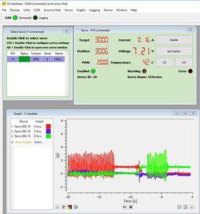
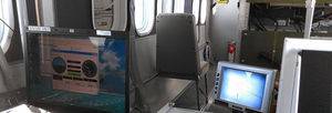
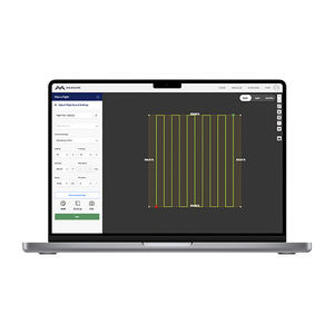
... The cEQUIP software is a powerful engineering and diagnostic tool that links all Currawong systems and allows for their configuration and real-time graphing and logging. The software connects to all products in the Currawong ...
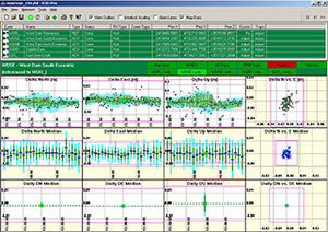
... RTD-Pro is a unique software solution for continuous monitoring of permanent GPS networks operating dual-frequency receivers.RTD-Pro provides Precise Instantaneous GPS positioning for the entire network. This allows robust real-time ...
Geodetics, Inc.

... FLIGHT PREPARATION FOR DRONE PILOTS MACH 7 Drone allows drone pilots to easily prepare their flights, by including all flights data in a single software: Flight preparation : date ...
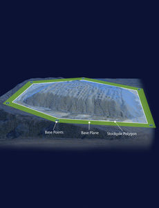
Data analysis and insightAutomatic data processing and secure online storage provide a solid foundation for quick or in depth analysis and simple reporting in an easy-to-use interface.Automated volumetrics and reportingThe Kespry Cloud automatically calculates ...
Our Cloud Service stores and processes the 3D point clouds and annotations to facilitate rich intelligent 3D models, making them available in near realtime to customers.
BrashTech
... AgVault is now FieldAgent™! The new name of Sentera’s agriculture software – FieldAgent Platform – better reflects our software’s broad range of capabilities and breakthrough analytics that are helping shape the future ...
the best suppliers