
Maximum load: 5, 9 kg
Autonomy: 2 h
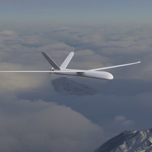
... GT20/ GT25 Gyrotrak is Airial Robotics‘ super versatile super Workhorse. A disruptive gyro/helicopter hybrid UAV solution advancing flight time, payload, range and speed over other systems. GT20/ GT25 is built for BVLOS with manned aviation ...

Maximum load: 10 kg
Autonomy: 90 min
... compliant mapping drone Designed to provide 1.5 cm / 0.6 in of absolute accuracy with available RTK / PPK and to cover an area up to 500 ha / 1,235 ac. Offering up to 90 minutes of flight time, the 1.6 kg / 3.6 lbs ...
AgEagle
... 2m Fixed Wing UAV This offer includes the following Services and Products: A tailor made 2m Fixed Wing UAV from the Concept to ready made platform that can carry your systems. Our Professions: Requirement analysis Concept ...
... commanders. Mapping 360 Skyview VR Drone technology has created a unique ability to offer a new level of imagery to the Google Earth and Bing mapping projects. By utilizing autonomous navigation, ...

Maximum load: 5 kg
Autonomy: 120 min - 150 min
Maximum altitude: 0'00" ft - 5000'00"
... survey and mapping solution. Development The GosHawk™ platform has been developed by V-TOL Aerospace to provide a low-cost, easy to use and reliable extended line-of-sight (LOS) ready mini-RPAS capable of conducting surveying and ...
V-TOL Aerospace
Maximum load: 7 lb
Autonomy: 90 min
... UNMANNED FIXED WING DRONE The Tempest was designed and engineered by Skip Miller Consulting specifically for the University of Colorado. The plane fit the University’s requirements for the National Science Foundation Tornado research ...

Maximum load: 2 kg
Autonomy: 59 min
Maximum altitude: 60 km
... landing) fixed-wing drone designed to meet the needs of drone mapping and inspections professionals, aerial imaging, precision agriculture, oil and gas, surveillance and monitoring, and more. The ...
FIXAR
Maximum load: 0 kg - 3 kg
Autonomy: 150 min - 180 min
Maximum altitude: 5,000 m
... Product Name : Accipiter Product Description Long Endurance : 2.5~3hr Max payload : 3kgs With RTK/PPK technique : NO NEED of GCPs Photo area(AGL 500m) : 30sq-km ...
Uaver
Maximum load: 3 kg
Autonomy: 2 h
Maximum altitude: 20 km
... is a mobile intelligence, command and control system designed to applications of short-range operations, such as: aerial mapping, surveillance and monitoring, data and information collection, and monitoring support in case of natural ...

Maximum load: 200 kg
Autonomy: 85 min
... SMALLEST and LIGHTEST professional hand-launched mapping drone Optimize surveying and mapping Boost intelligent digital industry Solutions for intelligent digital industry Accurate remote sensing data ...
Shenzhen Joyton Innovation Technology Co., Ltd.
Maximum load: 1 kg
Autonomy: 90 min
Maximum altitude: 3,960 m
... The E384 is one of the leading drones in the world for Agriculture, Surveying, Construction, Mining and Conservation applications. The E384 has been proven through thousands of hours of flight from hot and humid jungles to freezing mountains ...
Event 38 Unmanned Systems, Inc.
Maximum load: 2.5 kg
... All Easy Aerial UAVs are field-proven, NDAA Sec. 848 compliant, and built with qualified traceable components. Only American-made parts are used in critical systems, such as communications modules and flight controllers. All drones ...
Easy Aerial

Maximum load: 300 g
Autonomy: 50 min
Maximum altitude: 3,000 m
... designed for mapping. It is capable of carrying a 300 Gram payload. Most mapping cameras are under 300 Grams. The UAV is electrically powered with a very low dB level. The aircraft is fully autonomous ...

Autonomy: 2 h
Maximum altitude: 120 m
... payload bay supports the best mapping cameras available and custom integration. Vertical takeoff and landing: Fly from anywhere with autonomous VTOL capability. Vertical Takeoff and Landing VTOL Drone The Lynx VTOL ...
Swift Radioplanes

Maximum load: 5 kg
Autonomy: 12 h
... example mapping missions are ideal for the default cruise of 50 km/h. Furthermore, each wing contains control surfaces that maximise flight safety and trajectory accuracy, thereby adding further redundancy and control. Solar energy ...
... To address the unique needs of the world’s most complex industrial environments, Airobotics has developed a platform that is fully automated, industrial grade, on-demand and multi-purpose. ...

Maximum load: 7 lb
Autonomy: 210 min
... Ease of Use of a Multi-Rotor with the Flight Time of a Fixed Wing Deliveries commence March 2018 ENDURANCE AND POWER A maximum flight time of 3.5 hours or a maximum payload capacity of 7 lbs MOBILITY Aerodynamic design improves speed and mobility BALANCE A ...

Maximum load: 2.5 kg
Autonomy: 120 min - 240 min
... multirotor that provides up to 4 hours of operational flight time with only 25 kg MTOW. Its unique features make this hybrid drone a very versatile platform that will help you accomplish your missions faster than ever before. HYBRID ...
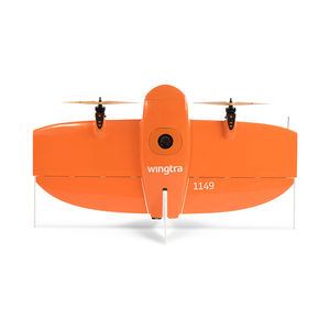
Maximum load: 800 kg
Autonomy: 55 min
... The Vertical Take-Off and Landing (VTOL) capability allows the WingtraOne to ascend and move like a helicopter. For the mapping mission it transitions into forward cruise flight and matches the endurance and speed of fixed-wing airplanes. ...
... MAX-8 Utility UAV v1.2 Photo Mapping Package Starting at $19,495.99 Now with improved vibration isolation for critical flight components and custom CNC mounting hardware, the MAX-8 V1.2 is even more rigid and reliable ...

Autonomy: 40 min
... UAV Mapper is an incredibly durable, affordable, commercial grade aerial mapping camera platform. The airframe was designed for the Pixhawk autopilot and carries popular UAV cameras including: Sony mirrorless ...

Maximum load: 500 g
Autonomy: 6,000 s
Maximum altitude: 3,000 m
... AVEM Amongst the very few drones dedicated to GIS data collection, the AVEM is unique thanks to its outstanding imagery quality, its BLOS certification and its ease of use. ...

... Engineered for professional, safe operations INEXA Control is an intuitive ground control station that lets you operate unmanned systems while staying compliant with emerging Federal Aviation Administration (FAA) regulations. As the commercial variant ...
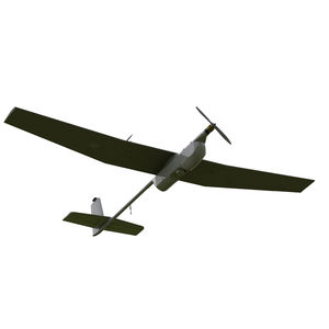
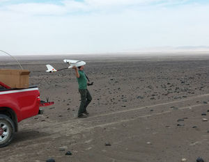
Insitu Inc
Maximum load: 1 kg
Autonomy: 0 min - 120 min
... easy transportation and intuitive operation are only a few of features this best-in-class UAS has to offer.AR4 Evolution main capabilities Fixed wing mini UAS designed for ISTAR Missions Focus on ease of use, transportability, ...

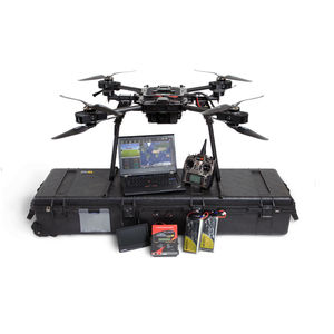
Maximum load: 15 kg - 60 kg
Autonomy: 2,400 s
Maximum altitude: 3,000 m
... -8 by SlidX, high capacities and smart features Dont purchase ready to wear when you can afford tailor made! We adapt our drones according to customer needs in terms of material structures and performance up to 120 kg- 264 lbs payload. ...
SlidX
the best suppliers