
{{product.productLabel}} {{product.model}}
{{#if product.featureValues}}{{product.productPrice.formattedPrice}} {{#if product.productPrice.priceType === "PRICE_RANGE" }} - {{product.productPrice.formattedPriceMax}} {{/if}}
{{#each product.specData:i}}
{{name}}: {{value}}
{{#i!=(product.specData.length-1)}}
{{/end}}
{{/each}}
{{{product.idpText}}}
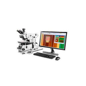
Fast, Efficient Inspection Workflows Stream Enterprise data management software offers intelligent step-by-step workflows to acquire sharp, crisp images that are ready for quantitative measurements and ...
Evident - Olympus Scientific Solutions
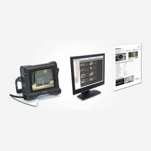
... image storage folders to your PC or tablet device*. *Confirmed with Toshiba FlashAir Wireless LAN SD card. 2. Image Management Image ManagementInHelp can display recorded images based on the section of your inspection ...
Evident - Olympus Scientific Solutions
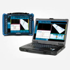
... data and generate reports using OmniPC 4 software. Using the PC-based software enables you to deploy the flaw detector in the field while performing analysis on previously acquired data acquired. OmniPC ...
Evident - Olympus Scientific Solutions

From route forecasting and terminal capacity management to airport resource allocation and strategic development planning, Leidos makes airport planning and forecasting easy. BEONTRA’s intelligent solutions solve your ...

... systems. It provides a robust solution that features remote troubleshooting/diagnostics and the capability of enabling remote software upgrades. Connecting into existing systems architecture, customers can monitor alarms, ...

... open architecture, scalable and cyber secure software platform that integrates security screening equipment, threat detection algorithms and other third-party data. As a centralized, enterprise management ...
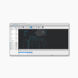
Eastman’s operating control software, CutPRO, is a dynamic, all-inclusive platform that makes it effortless to operate Eastman’s automated cutting system. Eastman’s operating control software is a ...
Eastman Machine Company
Eastman’s patternPRO is a design and nesting software. Its comprehensive set of tools help you design pattern pieces from the start with the program’s drafting and editing tools, or even edit and finalize your existing ...
Eastman Machine Company
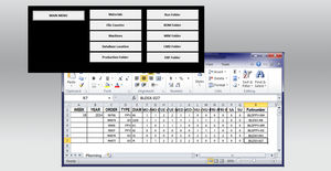
Eastman’s EasiSelect software organizes orders to generate a batch file for your nesting software. High-volume production facilities often complement their nesting software with EasiSelect ...
Eastman Machine Company

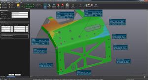
VXscan-R is an offline programming software that enables non-experts in 3D scanning or robotics to obtain optimal dimensional measurements in the shortest cycle time. With VXscan-R’s scanning intelligence and dedicated ...
Creaform

Scan-to-CAD software module The easiest-to-use reverse engineering toolkit for feature extraction and CAD modeling from 3D scan data Part of the Creaform Metrology Suite™, Scan-to-CAD is a post-treatment software ...
Creaform
Inspection software module The most flexible, comprehensive, and easy-to-use software solution for part inspections Part of the Creaform Metrology Suite™, Inspection is a comprehensive and powerful software ...
Creaform
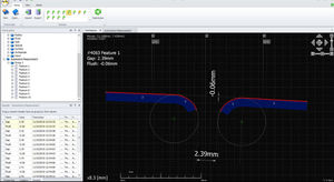
SPC3d is Third Dimension's world leading measurement and inspection software for GapGun profile measurement systems. SPC3d software, for both PC and onboard processing is designed to be fast, flexible ...
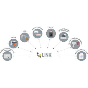
Integrate GapGun and Vectro measurement tools into your existing production systems using Link 01 INTEGRATION WITH A MEASUREMENT DATABASE Measurement requirements including tools, nominals and tolerances, and measurement results ...
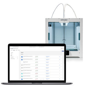
... you can drive innovation and efficiency across your network, manage users, and gain deep usage insights. Simple printer management Ideal for distributed teams, Ultimaker Digital Factory enables remote print job queuing ...
ULTIMAKER BV

... branch managers and the upper level managers at the headquarter of the organizations. Q-ViSTA software is CUSS 2.0 compatible. Hence it is one of the rare software applications using CUSS 2.0 standard.
QUAVIS

Q-KMS is a platform developed to configure and manage the kiosks and their hardware components connected to airline/airport systems. It was designed with the guidance of IATA Common Use Self Service (CUSS) principles. Q-KMS platform ...
QUAVIS

Q-SBD software provides automated baggage check-in to passengers. Q-SBD runs on KMS+ALAPP Platform. Q-SBD also runs with Q-CHECKIN as integrated.
QUAVIS

... reporting Some users require the functionality to attach a LanTEK IV test report file to link with records in a cable management software program, in order to streamline reporting. So, a function to ...

data collection softwareHappyOrNot Analytics
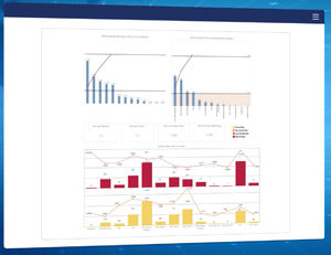
... data insights HappyOrNot delivers actionable data that empowers you to make informed decisions. Our proprietary analytics software provides detailed reports, visualizations, and trends, helping you instantly understand ...

Smiley Digital™ Deliver seamless omnichannel passenger experiences In today's digital age, customer feedback goes beyond physical terminals. Our digital solutions enable customers to measure the online customer satisfaction KPIs ...
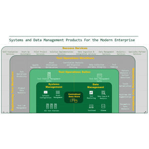
... and Data Management environment that breaks down silos in your organization—from concept to manufacturing. Designed for engineering use cases, SystemLink software combines focused applications and data ...
National Instruments
... Geographic Information System) software, also working in Open-Source, that allows the management of existing obstacles, in addition to the possibility to identify new ones by means of three-dimensional ...

... data, enable the development of a Digital Twin—an advanced virtual replica that facilitates predictive maintenance, cost management, and strategic planning. Operating in full compliance with international regulations ...

... other data. Account Management Role Management: Create teams and assign roles such as administrator or pilot. Authority Management: Distribute operation permissions based on assigned ...
Intelligent Software We all know your needs TimCloud UAV Management & Control Platform opens a new chapter of industrial application for you TimCloud UAV management and control platform ...

A unique online verification system that allows airlines to check whether a passenger possesses the correct documentation for their journey across all customer helpdesk and gate applications. It is the ideal tool to help airlines eliminate ...
ICTS Europe Systems Ltd

... designed to solve the issues faced by airports and carriers using traditional common use self-service systems. Combining proven software and hardware to deliver a simpler self-service solution for carriers. The ideal ...
ICTS Europe Systems Ltd

Ready to Go is a universally applicable web solution that automates the process of verifying travel and health documents to provide airlines and passengers with a fast and seamless process from home to gate. The solution offers airlines ...
ICTS Europe Systems Ltd
... days for the license key to be generated. Description Intelligent Photogrammetry: Agisoft Metashape is a cutting edge software solution, with its engine core driving photogrammetry to its ultimate limits, while the ...
The leading photogrammetry software for professional drone mapping Capture Capture RGB, thermal, or multispectral images with any camera. Any camera. Any drone. Any imagery. As long as it’s a .jpg or a .tif. Digitize Pix4Dmapper’s ...
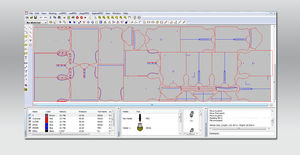
Management of Punches, Dies, Turrets...Lantek Expert Punch manages Autoindex tools, MultiTool stations, and all tool types from the most standard tools to tools for forming, embossing, drilling, threading, stamping, rolling, ...
Lantek Systems Inc

SmartSpace® is a highly-configurable software platform that tracks the real-time location, interaction and status of both people and objects in physical spaces. SmartSpace® benefits a wide variety of industries, making ...
EnTrack Platform focuses on Productivity Enhancement & Execution with Cost-Out and Profit-In as its mainstay while addressing all the operational elements to improve the Working Capital and Operating Cycle scenarios. The Platform delivers ...
TrackIT Solutions
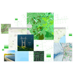
... data quality control workflows to enable the delivery of geospatial data you can trust. Use Data Reviewer to lower data management costs and reduce risk in decision-making by detecting, managing, and reporting errors ...
ENVIRONMENTAL SYSTEMS RESEARCH INSTITUTE, INC.

... comprehensive cargo management system. It supports multiple carriers’ accounting, rating and reporting requirements within a single platform, thereby eliminating the need for carrier specific terminals. Flexible schedule ...
CHAMP Cargosystems (UK) Ltd

Imagine what you could do with flight information, 365 days in advance. How could that enhance your operational efficiency? Find out with Amadeus AODB. It holds the schedules for 95% of the world’s airlines, a full year in advance. Plan ...
Amadeus IT Group SA

A powerful PC environment for today's smart production Stäubli Robotics Suite is a broad PC software environment which simplifies managing your robot system. Starting from conception and simulation over setup to production, ...
STÄUBLI

Provides all-in-one server solution for geospatial data management LuciadFusion lets you manage your data intelligently, store and process a multitude of data formats and feed data to numerous applications, putting ...
HEXAGON METROLOGY SAS

... Information Management gives us a clear and complete understanding of the environment that you are a part of. Manual data entry reduction, decrease of data inconsistency over the complete aeronautical data chain and efficient ...
INDRA
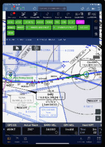
... Connected FMS The Connectivity Ecosystem brings a connected, open, and data-rich environment enabled by Flight Operations, Maintenance, and Avionics life cycle support applications. Smart Flight Planning Vertical ...
Universal Avionics Systems Corp.
Please specify:
Help us improve:
remaining