
{{product.productLabel}} {{product.model}}
{{#if product.featureValues}}{{product.productPrice.formattedPrice}} {{#if product.productPrice.priceType === "PRICE_RANGE" }} - {{product.productPrice.formattedPriceMax}} {{/if}}
{{#each product.specData:i}}
{{name}}: {{value}}
{{#i!=(product.specData.length-1)}}
{{/end}}
{{/each}}
{{{product.idpText}}}
... Overview
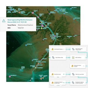
ArcGIS Velocity is a real-time geospatial analytics and mapping extension for the ArcGIS platform that connects live location data from sensors, assets, and external feeds to deliver immediate maps, dashboards, alerts, and automated ...
ENVIRONMENTAL SYSTEMS RESEARCH INSTITUTE, INC.

NETVIBES' insights-driven decision-making enables enterprises to listen, learn and act on all the information that matters to their business. Aggregate content from across the social web alongside enterprise data. Analyze business metrics in their social ...

... Why choose CAE’s Flight Management Solution? Achieve maximum savings with lower cost flight plans Reach superior fuel economy with real-time data and predictive tools to optimize routes, before take-off and while in the air Improve experience ...

... Optimize pre-departure sequences, maximize airport runway capacity and improve on-time performance even in adverse conditions with Amadeus Airport Sequence Manager. Optimize departures and maximize your airport runway capacity Amadeus Airport Sequence ...

... Cloud multiplatform USSP (U-space Service Providers) with a scalable design that enables end-user to fly their drones safely The UTM Connect is the multi-platform USP (Unmanned Service Provider) in charge of connecting a drone with the rest of the ...
INDRA

... Cargospot Revenue is a tried and tested cargo revenue accounting system that’s fully integrated with our other solutions to help you enhance productivity, improve cash flow and boost your billing performance. Comprehensive stock management Fully automated ...

... CAST Terminal provides scalable and realistic models of airport terminals and other passenger handling facilities. It enables decision support for planning, design, capacity analysis and optimization of terminal infrastructure and operational processes. CAST ...
... remote/oceanic operations (including Minimum Navigation Performance Specifications (MNPS) airspace), making it possible to obtain approval for remote/oceanic operations using GPS as a primary means of navigation. The ...
Universal Avionics Systems Corp.
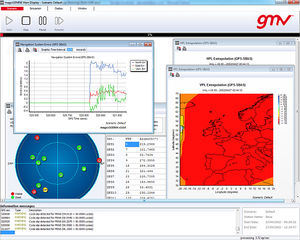
... specifically designed to meet the needs of air navigation service providers and airspace users. The MagicGEMINI® design is multi-constellation oriented, so it supports performance analyses for operational navigation ...
GMV
The flight planning features in SkyDemon are all designed to make planning a flight less tedious and more interesting, by bringing the very best aeronautical briefing information directly to your fingertips in real time as you explore our charts and experiment ...
SkyDemon

... Collaborative Decision Making tool INFOPAX A-CDM is an airport management tool based on the sharing of information between the various stakeholders in order to improve airport efficiency. INFOPAX A-CDM relies on aircraft rotations, as well as the ...
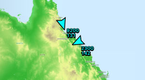
... Live in-flight tracking via 3G/Cellular networks or satellite. Your location can be shared with others via the avplan-efb.com website. If you do not turn up at your destination we have some idea of where to begin to search. AvPlan EFB even displays the ...
AvPlan EFB

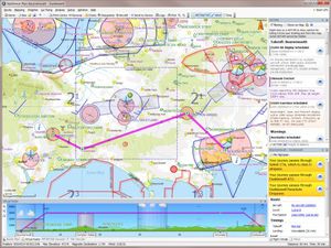
... digital-native generations, Polaris benefits from over 25 years experience in creating advanced, operationally-proven ATM software. Polaris ATM not only represents the latest industry technology, but its modular architecture enables the ...

... A-CDM Partners are listed below: The Airport Operator Aircraft Operators Ground Handlers De-icing Companies The Air Navigation Service Provider (ATC) The Network Manager Support Services (Police, Customs and Immigration, etc) ...
TAV Technologies
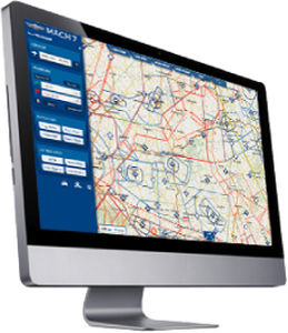
... MACH 7 is a next-generation software for flight planning and GPS navigation for VFR pilots. It associates the advantages of web and tablets. Its main characteristics are the following: Total intuitiveness: no user ...
MACH 7
SprayView allows you to create powerful flight reports. With both SprayView and NavViewW, you can create a detailed flight data report with spray data. SprayViewW allows you to create additional reports which can be customized with the information you ...
AG-NAV
... be saved and then opened with a standard Acrobat Reader. Click on the picture left to open example (Acrobat required). The software is also certified for Long-Term Data Archival and Retrieval (LOTAR) in the aerospace industry. Collision ...
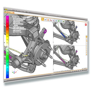
CORETECHNOLOGIE

... program code for hyperCAD®-S from scratch. The software architecture, the kernel, graphics, databases, user interface and API are all modern and based on 64-bit-technology. The result: decisive hardware and software advantages ...

... mission profile. The CDMM capabilities and modules are: • Enhanced navigation precision • Improved targeting and situation awareness • Certifiable Digital Map Generator airborne software (DO-178B level B compliant), ...
IDS INGEGNERIA DEI SISTEMI SPA

... Visualize, localize, and document your inspections with Inspector 4.0. An easy-to-use software solution developed to allow asset operators to make fast, data-driven decisions. Without the right management solution, acting on raw drone ...

... Complex Solutions for Airspace Users and ANSPs IXO SYSTEM represents a complex solution for airspace users and providers who look for a product that seamlessly integrates information on manned and unmanned aircraft operations and provides real-time ...

... Air Navigation Service Providers (ANSPs) around the world use the Aurora system and its advanced air traffic management capabilities to improve airspace efficiency and safety while delivering higher levels of service to airspace users. ...
ADACEL

... sensors, together with operational messaging, NOTAMS and status information to controllers. Document organization, storage, navigation and display features for charts, procedures and other data are all included. ...
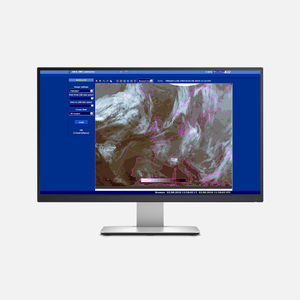
... IMS4 Briefing supplies meteorological information to aviation users in order to ensure the safety and regularity of air navigation. IMS Briefing workstation, either standalone or fully integrated within IMS4 AWOS, facilitates collecting ...
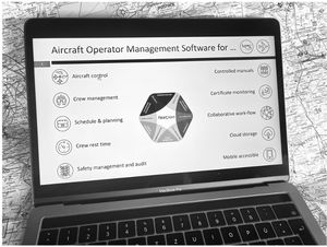
... FLEETPLAN Quality Management is the most comprehensive solution tailored for the specific needs of aircraft operators, design, maintenance and support organizations. Full 360° high performance management of regulation documentation implementation on ...
the best suppliers