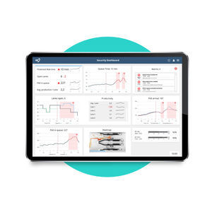
... The road to air transport recovery will be built on creating predictable experiences across the entire journey. But airports face immense pressure on delivering smooth operations with less resources and razor-thin budgets. Solving these challenges ...

... this cutting-edge software is optimized for industrial part slicing to make for a rapid, hassle-free start to printing. Built on industry-standard software with key features and optimizations: Specially designed ...
BIGREP GMBH

... position types – pseudo-pilots, controllers, - data preparation, instructors - Any number of airspaces, scenarios, airports and 3 D models ...
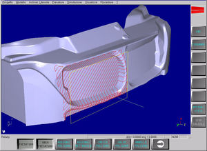
... HiMill is the Fidia CAM 3 D software for the manufacturing of moulds, dies, models and prototypes. It enables tool paths to be generated, from roughing out to super finishing, offering a wide choice of ...
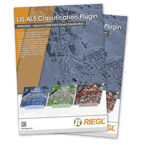
... relabelled as roof details and facade points. Vegetation is sliced into three vegetation heights (low, medium, high). Based on a 3 D search radius and the point count within this radius, non-vegetation points can be labelled ...
... multispectral & hyperspectral) Support for new LiDAR sensors 3 D map to better choose parts of the scan to extract as LAS Direct-georeferencing point cloud colorization (no need to wait for photogrammetry results) Tools ...

... advanced animation and X Y plotting features with window syncing to enhance results visualization. HyperView also saves 3- D animation results in Altair's compact H 3 D format ...
Altair Engineering GmbH
... accuracy. Create orthomosaics, digital surface models, contour and multispectral maps. View, export and share your 2 D and 3 D data files on an interactive, account-wide map. Measure linear distance ...

... Pressure from PIV software package meets the strong demand for direct extraction of full 3 D and 2 D pressure fields from PIV and Shake-the-Box (4 D-PTV) data. With only ...
LaVision GmbH
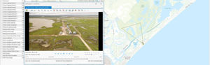
... The world's most comprehensive and flexible software for mapping, analysis, packaging and reporting using georeferenced videos, photos, documents/files and other sensor data from survey, inspection and surveillance data collection platforms. LineVision ...
... Fusion 360TM is the first 3 D CAD, CAM, and CAE tool of its kind. It connects your entire product development process in a single cloud-based platform that works on both Mac and PC. ...
Autodesk Inc

... Easily create accurate 3 D surface model maps from aerial photographs that can be exported to CAD and GIS applications. Your license can be activated on two devices: one device for on-site Rapid Check and one device for ...
... image taking plan is executed based on DatuSurvey™ best practice requirements, for quick image linkage, geo-referencing and 3 D models generation. ...
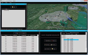
... the video cursor in the map window or by means of textual coordinate input; - View cartographic data and obstacles in 2 d and 3 d; - Interact with specific digital terrain models and obstacles delimitation ...

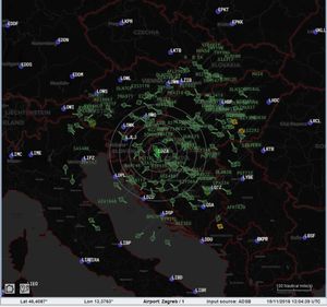
... MLAT and WAM. UNDERSTANDING HOW SURVEILLANCE SYSTEMS WORK The MLAT systems utilise advanced algorithms to deliver accurate 3 D location information. ADS-B solutions rely on aircraft or airport vehicles broadcasting ...
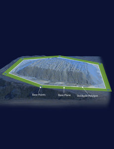
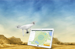
Data analysis and insightAutomatic data processing and secure online storage provide a solid foundation for quick or in depth analysis and simple reporting in an easy-to-use interface.Automated volumetrics and reportingThe Kespry Cloud automatically calculates ...
... Our Cloud Service stores and processes the 3 D point clouds and annotations to facilitate rich intelligent 3 D models, making them available in near realtime to customers. ...
... with the click of a button. Import KML files to use for future spray jobs. Export your flight and spray data to KML for direct 3 D, high quality viewing with Google Earth. Plan Your Flight SprayView allows you to plan ...

... the next level with the capabilities of Agisoft Photoscan Pro. Contact us to schedule a consultation to discuss how this software can help you model and break down data. ...

... training modules in 5 hours teach runway incursion prevention, airport ground operations, and ground-navigation safety, with a 3 D taxi simulator. Don't become a victim or a cause of runway incursions! Are you familiar ...
AVIATION TUTORIALS COMPANY, LLC
... Mode-A/C only, Mode-S, ADS-B) together with information about the target in configurable text form. In addition to the 2 D display, a 3 D view is featured to show the current traffic situation without ...
AVIONIX SOFTWARE S.L.
... training, and letting you spend time on mission rehearsal, not building databases. Additionally, with its 60HZ output, the 3 D scenes that GenesisIG creates are pinpoint sharp. “We chose GenesisIG in our Typhoon Dome ...
ANTYCIP SIMULATION

... The Reverse Engineering Module is used to analyze in detail an existing aircraft to figure out among other its aerodynamic efficiency (Maximum lift coefficient, maximum lift increment, friction coefficient, zero lift drag coefficient…) and its mass efficiency. The ...
OPTIMAL AIRCRAFT DESIGN
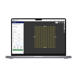
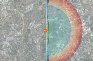
... NavPath Advanced Flight Planning Software for UAS NavPath is a modern UAS flight planning tool that combines an immersive 3 D environment, ease of use, and a powerful feature set to enable UAS operators ...
... Universal Control Software (UCS) is a central point where you can manage all your unmanned vehicles. It does not matter whether you have one drone or a fleet Tor Universal Control Software will suite your requirements. ...
the best suppliers