
... A forecast tool to help you plan your maintenance and ground time A complete solution designed for aircraft operators and maintenance shops. TracingNav© is a management tool to optimise aircraft fleet availability and foresee ground times. The ...
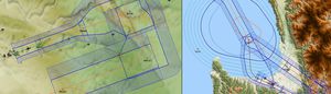
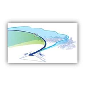
... GéoTITAN® In collaboration with l’Ecole Nationale de l’Aviation Civile (ENAC), CGX markets and develops GéoTITAN®, a software package used to design instrumented flight trajectories and identify protection areas, in a georeferenced aeronautical ...
CGX
CLOUD CAP TECHNOLOGY VIEWPOINT TASE PAYLOAD USER INTERFACE SOFTWAREKey FeaturesClick map or video to autonomously point payload at specific GPS location on the groundMulti-camera picture-in-picture displayInteractive map displays location and payload ...
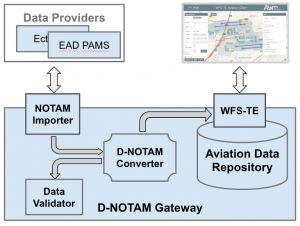
The Digital NOTAM Gateway imports text based NOTAMs and republishes them as AIXM Digital NOTAMs via a powerful WFS-TE interface. Among others, it is the perfect service for data portrayal, digital briefing and in-cockpit data visualization.The D-NOTAM ...

... . FDMS handles incomplete or inaccurate received messages simply and effectively by returning the message to an operator position and flagging it for their attention. The message can then be repaired, corrected and resubmitted to FDMS ...
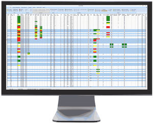
... CAMO Web Interface (CAM) Reliable surveillance and control of continuous airworthiness: Flight data recording and monitoring of maintenance due dates and due items Flight data entry and monitoring via web and manual Compliance check - eliminates error ...

... TerraLens Core (Formerly InterMAPhics), is the high-performance geospatial visualization and mapping software development kit at the heart of the TerraLens geospatial platform. TerraLens Core has been optimized for spatial awareness, ...

... Navigation+ Accurate and reliable data NAVBLUE has been producing navigation databases for over 30 years. It was the first company in the world to offer navigation data as a regular service, and draws ...
NAVBLUE
... AVIAGE SYSTEMS' navigation and guidance solutions are based upon GE TrueCourse™ Flight Management System (FMS) which manages and optimizes an entire flight plan. •AVIAGE SYSTEMS' IMA platform hosts the FMS ...

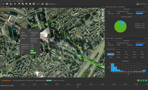
... A complete solution for managing your drone program, including team and fleet management, flight planning, data validation, processing and analytics. Centralize mission information All your mission information in one place, from scheduling, flight ...
senseFly
... Covers all aspects of the airport operation and it can run in multi airport mode, serving independent airports or a family of airports. Cover all the aspects of your airport operations with PDC AODB and connect with all the other vital systems like ...
PDC A/S
... In order to accurately register all aircraft movements at an airport, much is often still recorded by hand. Now that aircraft are equipped with mode-s transponders AirFee can significantly reduce the workload. With the help of a receiver, AirFee can ...
... ArView PC Software can be used to configure ArNav devices and view navigation data. ArView PC Software supports following features: Magnetic Calibration Data View Device Settings 3d ...

... -certified by European Data Protection Authorities. Ariadne has been benchmarked by the Indoor Positioning and Indoor Navigation Community, and found to be more accurate than Google's ARCore, IBM's Beacon Based Tracking, and Samsung's ...

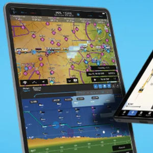
... Aurora gives you the tools you need to plan, build, test, manage, visualize, file, and up-link flight plans to your aircraft’s Flight Management System (FMS) from any location in the world, at any time, by using a variety of communication ...
SKYPLAN

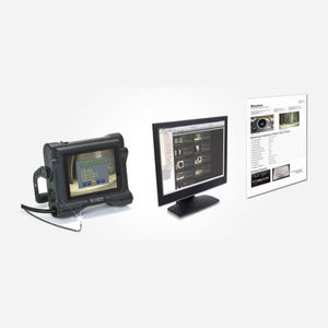
... The OXYGEN measurement software is the most intuitive and easy-to-use software in the data acquisition sector, designed to be operated via touchscreen or classical mouse and keyboard. Its nice instruments and controls ...

... reduced cost. And thanks to its process control data, you’ll always know who printed your parts and when, and what printer/ software version was used. Benefits + Features AI feature detection Select from critical part features that ...
... solution 1. On-site Inspection On-site Inspection InHelp can store images in folders dedicated to a section of your inspection. Navigation from one inspection section to the next is a one-touch operation. This provides a fast and effective ...
... and install database updates for compatible avionics. It centralizes purchase, scheduling and installation workflows for
navigation and obstacle data, with references to bundle options and update pricing.
Available videos ...
Garmin International, Inc.
... optimally for your trajectory in order to achieve the best position accuracy. Image geo-tagging for Photogrammetry Qinertia simplifies the photogrammetry workflow by adding precise position and orientation to JPG ...
... and is compliant with the requirements of AS9115. RDDS Key Software Development Capabilities: DO-178 DAL B/C Design DO-254 DAL B/C Design Bespoke Firmware Development Bespoke Software Applications AS9100 and ...
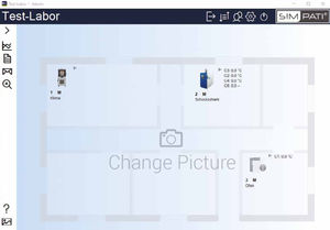
... weisstechnik presents the new version of the proven control software in a new design, with practice-oriented menu navigation and high-performance evaluation. S!MPATI® not only offers operating efficiency and performance, ...

In addition to manual flight, the MikroKopter can also automatically fly waypoints. Routes or individual points can be planned in advance in the office and stored into a misson plan. Based on these waypoints the MikroKopter can map a terrain, take panoramic ...
the best suppliers