
{{product.productLabel}} {{product.model}}
{{#if product.featureValues}}{{product.productPrice.formattedPrice}} {{#if product.productPrice.priceType === "PRICE_RANGE" }} - {{product.productPrice.formattedPriceMax}} {{/if}}
{{#each product.specData:i}}
{{name}}: {{value}}
{{#i!=(product.specData.length-1)}}
{{/end}}
{{/each}}
{{{product.idpText}}}

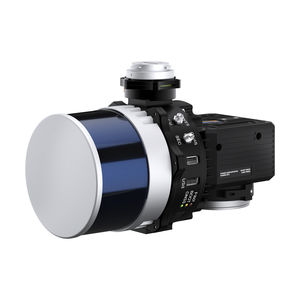
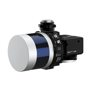
... device via a simple web inter- face. RESEPI HESAI XT-32 Compact and light-weight, the RESEPI XT-32 featuring a Hesai LiDAR scanner, is all-around a very attractive system, offering the benefits of best-in-class data ...
Inertial Labs, Inc.
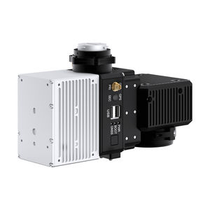
... via a simple web interface. RESEPI XT-32M2X makes use of Hesai’s enhanced M2X LiDAR scanner which features lighter weight and extended detection over the XT-32 LiDAR. This enables an M2X equipped ...
Inertial Labs, Inc.
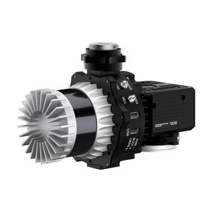
... with AVIA LiDAR is the lightest configuration, coming in at below 1kg. This enables longer flight times and increases the selection of drone platforms ton include those with lower payload capacity. The narrow scan field of view concentrates ...
Inertial Labs, Inc.
... 0.05 deg Heading Precision (Point Cloud): 3 - 5 cm (dependent on LiDAR, taken on the same target @ 50 m AGL) Scanner field of View (FOV): 360 deg (depend on LiDAR selection) Scanner ...
Inertial Labs, Inc.
... 0.05 deg Heading Precision (Point Cloud): 3 - 5 cm (dependent on LiDAR, taken on the same target @ 50 m AGL) Scanner field of View (FOV): 360 deg (depend on LiDAR selection) Scanner ...
Inertial Labs, Inc.
... 0.05 deg Heading Precision (Point Cloud): 3 - 5 cm (dependent on LiDAR, taken on the same target @ 50 m AGL) Scanner field of View (FOV): 360 deg (depend on LiDAR selection) Scanner ...
Inertial Labs, Inc.

... The next-generation of integrated UAV LiDAR solutions. With Livox technology, YellowScan sets new standards for UAV LiDAR mapping. YellowScan Mapper LiDAR system YellowScan is committed to delivering ...
HEIGHT TECH Benelux B.V.

... The next-generation of integrated UAV LiDAR systems, a long-range & multi-platform LiDAR solution offering more system accuracy at much higher altitudes. YellowScan Explorer LiDAR system YellowScan ...
HEIGHT TECH Benelux B.V.
the best suppliers