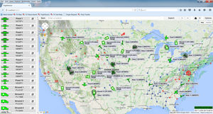
... FLIGHT VECTOR MAP Flight Vector™ Map provides the user with enhanced situational awareness of the organization’s operations by providing: A complete overview of all assets and their current locations Real-time weather and airspace restrictions Current ...
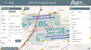
Lightweight, web based Aviation Client application for aeronautical information portrayal and visual data validation. It supports multiple map layers (for weather and terrain data) and provides a tool for spatial and temporal WFS 2.0 query building with ...

... TerraLens Core (Formerly InterMAPhics), is the high-performance geospatial visualization and mapping software development kit at the heart of the TerraLens geospatial platform. TerraLens Core has been optimized for spatial ...
KONGSBERG GEOSPATIAL
... Charts+ Your complete digital charts! Charts+ is a ready-to-use set of digital charts (IFR, terminal, en route) that draws on information published by national Aeronautical Information Services. Updated according to the 28-day AIRAC schedule, Charts+ ...
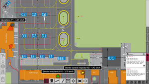
... Common Operating Picture AirMap is an airport visualisation platform which supports airport operators to face one of the biggest challenges in a dynamic environment: keeping track of what is happening and where it is happening. AirMap displays all relevant ...

With PADS4 create your interactive map and let yourself be guided. Whether you are looking for a store, a person or a workspace in a company, a service in a public place or your gate in an airport, PADS4 Wayfinding will be able to adapt and personalize ...

... official reseller of the Pix4D software in Finland, meaning you can buy the software license directly from us. Pix4Dmapper Pro license for one user (installation possible on two devices) is an extremely versatile tool ...
the best suppliers