
{{product.productLabel}} {{product.model}}
{{#if product.featureValues}}{{product.productPrice.formattedPrice}} {{#if product.productPrice.priceType === "PRICE_RANGE" }} - {{product.productPrice.formattedPriceMax}} {{/if}}
{{#each product.specData:i}}
{{name}}: {{value}}
{{#i!=(product.specData.length-1)}}
{{/end}}
{{/each}}
{{{product.idpText}}}
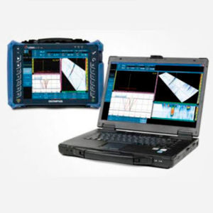
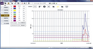
... data and generate reports using OmniPC 4 software. Using the PC-based software enables you to deploy the flaw detector in the field while performing analysis on previously acquired data acquired. OmniPC ...
Evident - Inspection Technologies
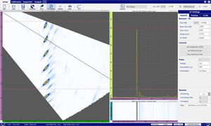
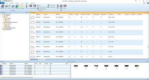
... further, WeldSight software’s tools enable inspectors to conduct thorough analyses that comply with strict validation requirements of international or internal standards. Efficient Workflow for Weld or Corrosion Inspection WeldSight ...
Evident - Inspection Technologies
... data and generate reports using OmniPC 4 software. Using the PC-based software enables you to deploy the flaw detector in the field while performing analysis on previously acquired data acquired. OmniPC ...
Evident - Inspection Technologies

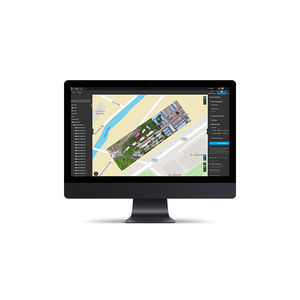
... systems. It provides a robust solution that features remote troubleshooting/diagnostics and the capability of enabling remote software upgrades. Connecting into existing systems architecture, customers can monitor alarms, ...

ProSight™ is an open architecture, scalable and cyber secure software platform that integrates security screening equipment, threat detection algorithms and other third-party data. As a centralized, enterprise management ...

From route forecasting and terminal capacity management to airport resource allocation and strategic development planning, Leidos makes airport planning and forecasting easy. BEONTRA’s intelligent solutions solve your planning and forecasting ...
Eastman’s operating control software, CutPRO, is a dynamic, all-inclusive platform that makes it effortless to operate Eastman’s automated cutting system. Eastman’s operating control software is a ...
Eastman Machine Company
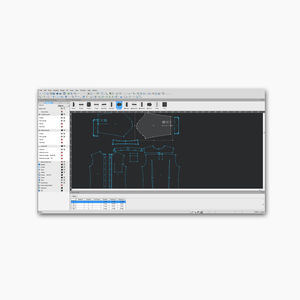
Eastman’s patternPRO is a design and nesting software. Its comprehensive set of tools help you design pattern pieces from the start with the program’s drafting and editing tools, or even edit and finalize your existing ...
Eastman Machine Company
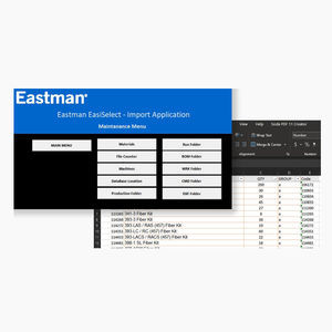
Eastman’s EasiSelect software organizes orders to generate a batch file for your nesting software. High-volume production facilities often complement their nesting software with EasiSelect ...
Eastman Machine Company

AFIS for civilian identification. The Automated Fingerprint Identification System (AFIS), representing DERMALOG’s core product, is continuously improved in order to further guarantee reliable products: the algorithm to identify fingerprints ...
DERMALOG Identification Systems
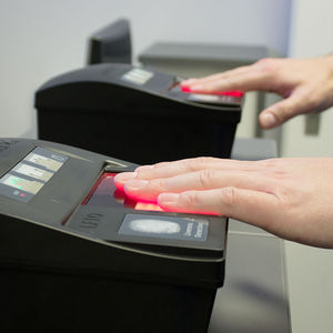
... Automated Fingerprint Identification System in the world - the DERMALOG AFIS. As confirmed by the renowned test SGS-TÜV Saar, the software allows the processing of almost 3.6 billion matches per second. Despite its speed, ...
DERMALOG Identification Systems
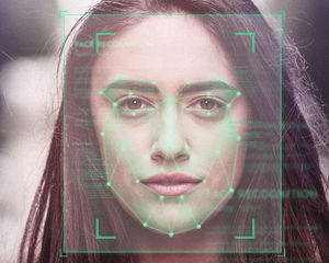
... mobile solutions and border control: Face matching software by DERMALOG are part of border control in several countries. DERMALOG Face Recognition – Security taken to another level DERMALOG’s software ...
DERMALOG Identification Systems
Produce high-performance parts with a powerful and intuitive software The power of Roboze, made simple Prometheus is a slicing software created and developed by Roboze to utilize your Roboze 3D Printer ...
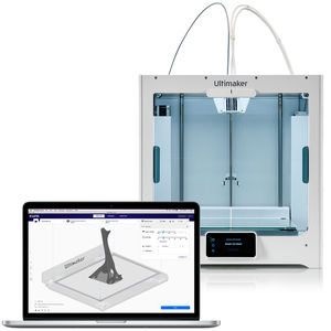
Trusted by millions of users, Ultimaker Cura is the world’s most popular 3D printing software. Prepare prints with a few clicks, integrate with CAD software for an easier workflow, or dive into custom ...
ULTIMAKER BV
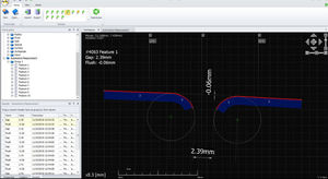
SPC3d is Third Dimension's world leading measurement and inspection software for GapGun profile measurement systems. SPC3d software, for both PC and onboard processing is designed to be fast, flexible ...
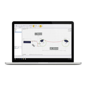
ULTRA-FLEXIBLE QUALITY INSPECTION SOFTWARE THE ULTIMATE ANALYSIS TOOL Inspect is the ideal tool for replacing old contracer and shadowgraph techniques. Use Inspect with GapGun or Vectro laser measurement systems ...
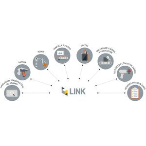
Integrate GapGun and Vectro measurement tools into your existing production systems using Link 01 INTEGRATION WITH A MEASUREMENT DATABASE Measurement requirements including tools, nominals and tolerances, and measurement results ...

Smiley Digital™ Deliver seamless omnichannel passenger experiences In today's digital age, customer feedback goes beyond physical terminals. Our digital solutions enable customers to measure the online customer satisfaction KPIs ...

data collection softwareHappyOrNot Analytics
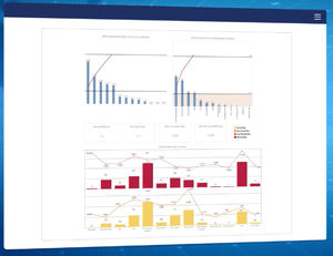
... data insights HappyOrNot delivers actionable data that empowers you to make informed decisions. Our proprietary analytics software provides detailed reports, visualizations, and trends, helping you instantly understand ...
... days for the license key to be generated. Description Intelligent Photogrammetry: Agisoft Metashape is a cutting edge software solution, with its engine core driving photogrammetry to its ultimate limits, while the ...
... business days for the license key to be generated. Description Intelligent Photogrammetry: Agisoft Metashape is a cutting edge software solution, with its engine core driving photogrammetry to its ultimate limits, while ...
The leading photogrammetry software for professional drone mapping Capture Capture RGB, thermal, or multispectral images with any camera. Any camera. Any drone. Any imagery. As long as it’s a .jpg or a .tif. Digitize Pix4Dmapper’s ...
... 3D reconstruction software with cloud or local processing, utilizing deep learning for highly accurate results. Swift and Accurate Autel's AI deep-learning algorithms make Autel Mapper the one of the quickest map ...
AUTEL EXPLORE THE WORLD
Intelligent Software We all know your needs TimCloud UAV Management & Control Platform opens a new chapter of industrial application for you TimCloud UAV management and control platform is a monitoring and control ...

... Consider the Test Workflow bundle for LabVIEW and more NI Software. Licenses are sold as one-year subscriptions that include access to online training, degreed engineers for technical support, and software ...
National Instruments

... improve your daily operation. See the full release notes here. Here are six reasons you can depend on the new LanTEK IV software updates to help you get the most out of TREND AnyWARE Cloud on every job. Simplified ...

Agilent MicroLab Mobile software uses the same framework as the PC version of the software, but on a mobile platform, allowing users to select a variety of methods with the click of a button. With MicroLab ...
All of the Lantek Expert Cut options are integrated into one program. Lantek Expert is fully integrated with Lantek Integra, an ERP which offers different CAD/CAM/MES/ERP solutions for the sheet metal and fabrication sector. Additionally, ...
Lantek Systems Inc

SmartSpace® is a highly-configurable software platform that tracks the real-time location, interaction and status of both people and objects in physical spaces. SmartSpace® benefits a wide variety of industries, making ...
Vaisala NM10 is a software solution that can be used together with Vaisala sensors and weather stations to collect, visualize, and report business-critical weather and air quality observation data. By providing timely, ...
VAISALA OYJ

Scan-to-CAD software module The easiest-to-use reverse engineering toolkit for feature extraction and CAD modeling from 3D scan data Part of the Creaform Metrology Suite™, Scan-to-CAD is a post-treatment software ...
Creaform
EnTrack Platform focuses on Productivity Enhancement & Execution with Cost-Out and Profit-In as its mainstay while addressing all the operational elements to improve the Working Capital and Operating Cycle scenarios. The Platform delivers ...
TrackIT Solutions

A powerful PC environment for today's smart production Stäubli Robotics Suite is a broad PC software environment which simplifies managing your robot system. Starting from conception and simulation over setup to production, ...
STÄUBLI
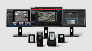
... standard system link, web reports and much more. Built with the flexibility to grow as user requirements change, AC2000 software licensing and CEM readers/controllers can be easily expanded to support a unlimited numbers ...
CEM Systems
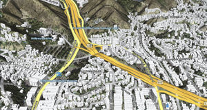
Provides all-in-one server solution for geospatial data management LuciadFusion lets you manage your data intelligently, store and process a multitude of data formats and feed data to numerous applications, putting the power of your ...
HEXAGON METROLOGY SAS

A centralized ATM system that applies the latest technology in the market, laying out its own roadmap fully aligned with EUROCONTROL, SESAR and ICAO ASBUs definition and evolution strategy. Our worldwide expertise and knowledge are crucial ...
INDRA
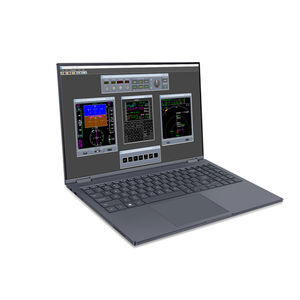
... Management System (FMS) Trainer Desktop Software The Flight Management System (FMS) Trainer Desktop Software Program provides interactive training for the SBAS-Flight Management Systems (FMS). The Windows® ...
Universal Avionics Systems Corp.

Why choose CAE’s Operations Control? Deliver elevated customer & employee experience Improve operational efficiency & performance Reduce costs & increase profitability The right solution for airline operators With a single ...
CAE
Please specify:
Help us improve:
remaining